
XenomatiX and the Road Scanning Solution
To address these challenges, XenomatiX offers the XenoTrack LiDAR system, a solution specifically designed for road inspection and mapping. XenoTrack is a vehicle-mounted, solid-state LiDAR system that integrates sensors, cameras, and GNSS positioning into a single platform. It operates at normal driving speeds while delivering millimeter-level accuracy, capturing even the smallest details of the road surface.
The system enables the generation of high-resolution 3D point clouds representing the road surface in detail. This allows for the detection of cracks, potholes, and surface irregularities, while also supporting the calculation of road quality indicators such as roughness, rutting, and other deformation metrics. Furthermore, the data is georeferenced, enabling the creation of digital road models and digital twins that can be integrated into GIS platforms for long-term monitoring and planning.
Enhancing Detection with Algorithms and Data Fusion
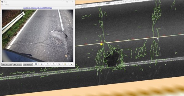
While XenoTrack provides highly precise data, the real strength of the system lies in the integration of advanced algorithms, models, and software tools that transform raw data into meaningful insights. LiDAR-based algorithms process 3D point clouds to analyze surface geometry, identify deviations, and measure deformations, enabling accurate quantification of road defects.
At the same time, camera-based methods use AI and deep learning techniques to analyze visual information, detecting cracks, texture variations, and surface damage that may not be fully captured through geometric analysis alone. The most advanced approach combines these two data sources using sensor fusion algorithms, aligning 2D camera data with 3D LiDAR data to create a unified model of the road surface. This integration significantly improves detection accuracy, reduces uncertainty, and provides a more comprehensive understanding of road conditions.
Improving Road Quality and Driving Safety
The combination of high-precision LiDAR hardware and intelligent data processing represents a major step forward in infrastructure management. By enabling early detection of defects, road operators can plan maintenance activities proactively, reducing long-term costs and extending the lifespan of infrastructure.
This approach supports data-driven decision-making by replacing subjective assessments with objective measurements and contributes to improved road safety by identifying hazards before they worsen. In addition, accurate road data is essential for advanced driver assistance systems (ADAS) and autonomous vehicles, which depend on reliable information about road conditions.
XenomatiX is actively collaborating with municipalities across Belgium and Europe to advance long-term digital road management solutions. Several common needs and challenges consistently emerge:
- Replacing subjective visual inspections with consistent, repeatable measurements
- Providing long-term road condition monitoring
- Enabling trend analysis of pavement deterioration
- Supporting strategic budget planning and maintenance prioritization
- Reducing the risk of costly road reconstructions through early intervention
In response, XenomatiX offers its 6D road scanning system combined with a comprehensive Pavement Management System (PMS), using the Pavement Condition Index (PCI) as a standardized metric to evaluate and track road health over time.
The XenomatiX platform enables municipalities to regularly monitor road conditions and organize this information within a structured GIS environment to improve maintenance planning. Instead of reacting to visible damage or complaints, authorities can identify deterioration trends, schedule repairs proactively, and allocate budgets more efficiently. This results in reduced long-term costs and better use of public resources.

Advancing Innovation Through the Cynergy Project
XenomatiX contributes to the project primarily through its role in the road-condition monitoring demonstrator, where it provides direct road-surface measurements using its LiDAR-based sensing technology. Its data forms a key layer within the multi-source Road Condition Map, complementing inputs such as camera-based assessments, crowd-sourced information, and satellite-derived risk data. These measurements are used to improve detection accuracy and reliability, supporting the broader objective of fusing heterogeneous data into actionable, interoperable information layers for safer and more efficient mobility systems.
Through optimized algorithms and efficient processing workflows, this initiative also supports the development of next-generation intelligent sensors capable of detecting road conditions in real time, communicating this information to other vehicles, and contributing to safer driving behavior.
Blog signed by: Xenomatix team